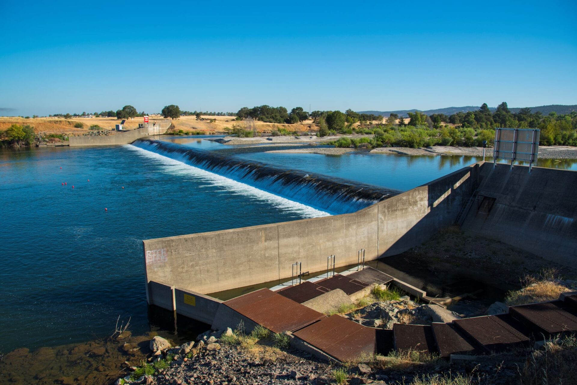
What To Do About Daguerre Point Dam?
The Daguerre Point Dam was built in 1906 by the Army Corps of Engineers to prevent the flow of debris from upstream mining operations into the Feather and Sacramento Rivers. But an archaic design and a lack of maintenance have made the dam a key obstruction to the traditional spawning habitat of native anadromous fish such as the Chinook salmon and California Central Valley steelhead. With the intent to protect native fish species and build a long-term solution with community stakeholders, SYRCL has applied for a grant through the National Marine Fisheries Service in order to get a better understanding of the opportunities and challenges related to improving volitional fish passage at Daguerre Point Dam and Englebright Dam in the Yuba River watershed.
During the Gold Rush, thanks to hydraulic mining, approximately 684 million cubic yards of mining debris were washed into the lower Yuba River. In 1884, the Sawyer Decision came down, which banned allowing any gravel, sand, and other hydraulic waste from mines getting into rivers that drain into the Sacramento and San Joaquin River watersheds, which effectively banned hydraulic mining (many smaller hydraulic operations continued, if they proved an effective debris damn installation — some small hydraulic mines were washing gravel as late as 1955) After the Sawyer Decision, this material was reworked via dredge mining. These events had a devastating impact on the ecosystem of the Lower Yuba River by first burying the natural floodplain and riparian corridor in up to 40 feet of mercury laden hydraulic mining debris, then the mine tailings were dredged 100 feet deep, through the hydraulic mining debris into the natural alluvial deposits on the riverbed, creating piles of mine tailings up to 80 feet tall.
Daguerre Point Dam and Englebright Dam were built as control structures to prevent hydraulic mining debris from continuing to cause channel build up and the subsequent increased flood risk associated with it to downstream communities. For the first 20 years after it was built, there was no fish passage at Daguerre Point Dam, limiting the anadromous habitat for all species to approximately 11 miles. Fishways at Daguerre Point Dam were first installed in 1927 – 1928, and the modern fish ladders were completed in August 1951. No fish passage currently exists at Englebright Dam.
The grant funding sought through the National Marine Fisheries Service will give SYRCL and community stakeholders the opportunity to engage in a good faith, values-based, collaborative process with stakeholders and the local community to collaboratively develop up to ten design alternatives to the current situation. These designs will: a) support upstream passage past Daguerre Point Dam for special status fish species, expanding their distribution and density in the lower Yuba River, b) do no harm to habitat or populations of existing special status species, c) maintain or enhance the efficiency of existing irrigation diversion infrastructure and reduce fish entrainment, and d) ensure that passage improvements are compatible with completed and planned restoration activities in the lower Yuba River.
In the pursuit of this goal, this project will work towards the modification of Daguerre Point Dam. Currently, the dam is a full barrier to green and white sturgeon and Pacific Lamprey and a partial barrier for steelhead and Chinook salmon, contributing to their population declines (NMFS 2012). The project team will also begin data collection and refine previously completed computer modeling to better understand the challenges associated with managing sediment at Englebright Dam. It will also establish a collaborative partnership framework, informed by existing scientific knowledge, that includes scientists, resource managers, restoration practitioners, policy makers, tribal leaders, and watershed stakeholders. This collaborative will work to develop a plan for removal or modification of Daguerre Point Dam.
The technical and scientific goals of this proposal include field studies and computer modeling to fill previously identified knowledge gaps which will inform the collaborative decision-making process. As part of this project, we will model how sediment moves through the lower Yuba River and how groundwater is recharged in and around Daguerre Point Dam. We will also conduct studies to better understand non-native fish species in the river and mercury concentrations in the water during winter storms.
SYRCL has submitted this grant application to the National Marine Fisheries Service to better understand the opportunities and challenges removing barriers to volitional fish passage at Daguerre Point Dam present. To ensure sustainability of improved fish passage at Daguerre Point Dam, SYRCL is also seeking funding for data collection and modeling to improve our understanding of sediment transport and river connectivity including the sediment impounded by Englebright Dam.
For more information about the grant application and the proposed project, please contact Aaron Zettler-Mann, SYRCL’s Watershed Science Director, at aaron@yubariver.org
Did you enjoy this post?
Get new SYRCL articles delivered to your inbox by subscribing to our ENews.

Hello Aaron –
Please edit the following paragraph within the SYCL website summary blog “What to do about Daguerre Point Dam” that state “In 1884, the Sawyer Decision came down, which banned allowing any gravel, sand and other hydraulic waste from mines getting into rivers,….
It should be changed to “In 1884, the Sawyer Decision came down, which banned allowing any gravel, sand and other hydraulic waste from mines getting into river that drain into the Sacramento and San Joaquin River watersheds….
NOTE: The Sawyer Decision only applied to mines discharging tailings into the Sacramento and San Joaquin River watersheds…..All other Sierran and Klamath Mountain rivers were exempt, particularly the Klamath River Basin, where hydraulic mining continued unabated until the late 1960’s
Best Regards,
David Lawler – SYRCL Member
Economic Geologist
Environmental Restoration Specialist
Sierra Geosciences Group
Grass Valley, CA
(Cell) (510) 499-6048
Thank you for this comment/correction.